RAILWAYS IN KORAPUT
When
we talk about the development of Railways in Koraput district we mean undivided
Koraput district, because the new districts of Koraput. Nabarangapur,
Malkangiri and Rayagada were carved from the old one on the 2nd
October 1992 only. All the Railway lines
in Koraput district are under Walteir division of East Coast Zone. The total length of Railway line in Koraput
District (Excluding) is about 113 Km. The stations in Rayagada district are
Jemadeipentha - Rayagada - Singapore
Road - Theruvali - Bissumcuttack Muniguda - Daikhll - Ambadola. The total
length of 158 Km (i.e. in Orissa) is in Koraput district. The stations which
are in Koraput district are Darliput - Padua - Bijaguda - Machkund road -
Paliba - Telaput - Koraput - Manabar - Jarti - Maliguda - Jeypore - Hadia-
Kusumi - Kotpad. The total number of stations in this line is 42 Nos. There are
46 Tunnels, having total length of 12.76 Km, out of which 9.81 Km are with steel
concrete lining.
1. Maliguda Tunnel
is the highest broad gauge tunnel in India.
It is about 50 Kms from Koraput Railway station and 25 Kms from Jeypore
Railway station.
2. This was the
highest broad gauge line in the world.
3. Semiliguda
station (Andhra Pradesh) is the highest broad gauge station in India. It is 15
Kms from Aruku.
Koraput - Rayagada Rail
line :- was constructed in two phases.
(i)
The first phase work, i.e. Koraput
Damanjodi line was completed in 1985.
(ii)
The Hirakhand Express (Koraput to Bhubaneswar)
started in December 1997.
(iii)
There are altogether 12 stations
enroute. There are 36 Tunnels and the longest tunnel is 16 Km.

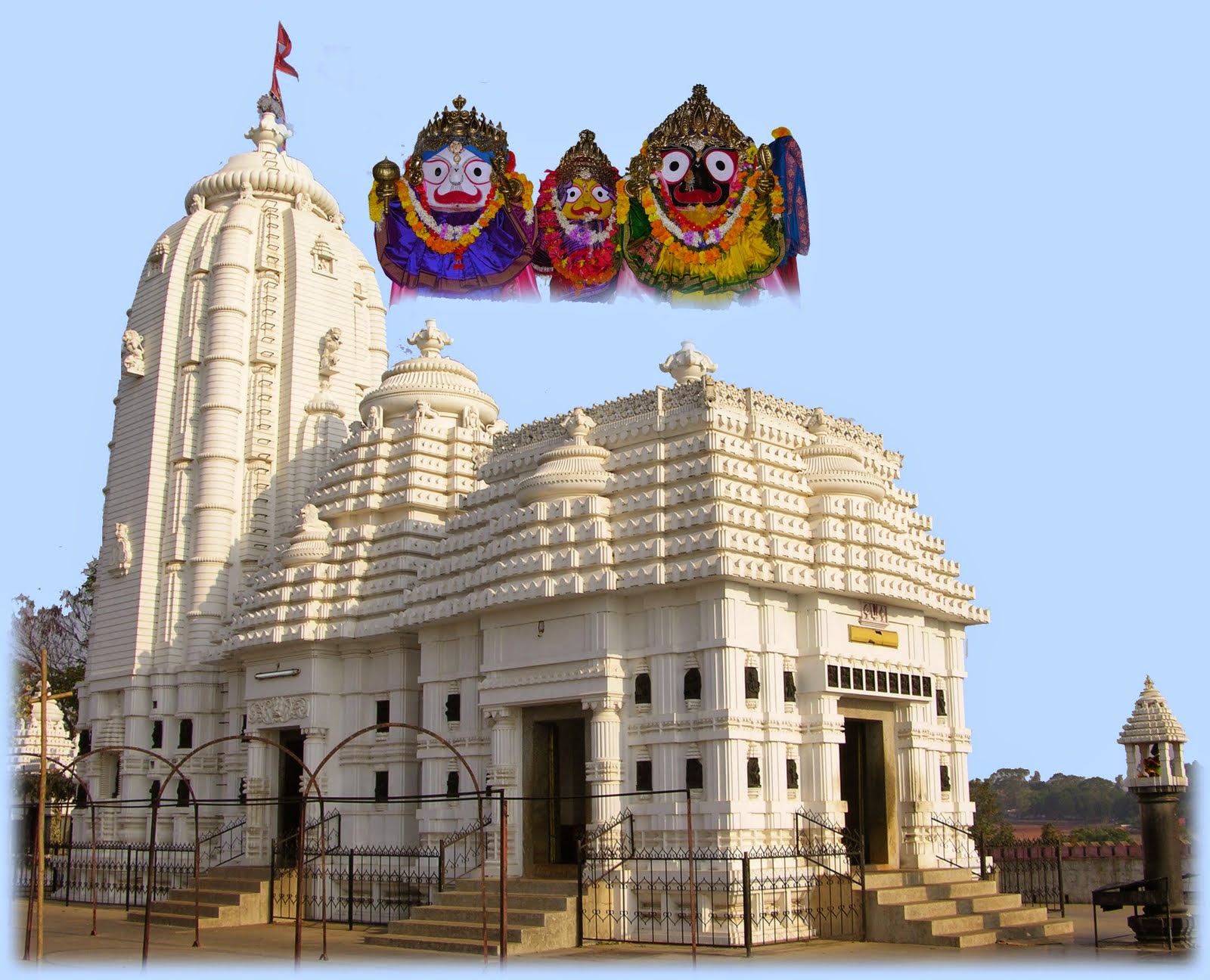
JAGANNATH
TEMPLE:-
The headquarter Town of Koraput is also famous for its
for places is cerise known Sri. Jagannath Temple, as the Sabara Srikhetra, is the
biggest Temple of the District, which has been constructed in the 19th
Century. Now a days, this temple is the
main attraction for this town. The
famous Ratha Yatra is also celebrated here in a grand way. The Temple is surrounded with a boundary
wall. In order to reach at the Temple,
one has to climber more than 100 steps, to see the Lord Jagannath. The height
of the temple rises to about 50 feet and has a four chambered Complex with
Deula, Jagamohan, Nata Mandapa, and Bhoga Mandapa, closely affixed to each
other. By 1982 all the side deities were
established a round the Temple. Lord Jagannath, Balabhadra, and Subhadra are
worshipped in the main sanctum of the Temple.
The Temple of Lord Jagannath, is located on the top of a hillock. Important deities have been installed there
in and around the Temple. It attracts
quite a large number of tourists from neighbouring areas each year. A tribal museum is situated near the Temple
site. In the Museum collections of articles
related to the life styles of different tribal groups, their cultural and
economic life, musical instruments and mant other things. It maintains a well
developed library rich with books on tribes.
Some people go to the extent of saying that the Jagannath
cult which found its highest manifestation at Puri has originated from
Koraput. The imposing Temple of Lord
Jagannatha on the top of the Nisan Pabli (Pabli is the Desia term for hillock),
renamed as “Nilasaila” in the centre of Koraput, dominating the structural
landscape of the town, had a momentous beginning.
The devotees steal a devotional glance of almost all major
deities of the Hindu pantheon, such as Mahabira Hanuman, Maha Ganesh, Surya,
Laxminrusingam, Bimala, Maha Saraswati, Patar Sauruni (Lalitambike) Mahalaxmi,
and the Nabagraha and the Dolo Mandapa, as they go round (Pradaksana) the Lord
in the main enclosure (Bedha).
ABOUT
KORAPUT DISTRICT:-
The
erstwhile Koraput district was divided into four districts, viz. Koraput,
Nowarangpur, Malkangiri, and Rayagada in 1992.
This Undivided Koraput district was one of the largest districts (Second
in rank) in the Country with an area of about 27,020 Sq. Kms. This un-divided
Koraput district was first constituted as a district in 1st April
1936, when the province of Orissa came into existence. Before that date it was
a part of the Vizagapatam district of Madras Presidency. This un divided
Koraput district is the largest with tribal concentration of 54.30% Koraput is
a hilly district in the Eastern Ghats Region of South Orissa. The district Head
Quarter i.e. Koraput is situated at an altitude of 966m above Sea level.
JEYPORE :-
Jeypore town located at a distance of
22 Km from Koraput. Is the biggest town main
trading centre of Koraput Distric. One
can make it a base point to visit the other tourist places The Jagannath Sagar
is situated in western of the town part.
It is a very big tank of 1.25 Km 10.75 Km size. The presiding deity of Jeypore is the Jagat
Janani. There is also an art school in the town. The town has quite a good number of Luxury
hotels where tourists can stay. Jeypore, otherwise called the city of victory is
also a famous centre of Jainism. Jeypore
has a college named after Maharaja Vikramdev and three high schools the only
art school is also named after the Maharaja. There is also a beautiful old
Church. The Dasahara festival is a
great event of the year in Jeypore town.
It lasts for 16 days with much pomp and grandeur in honour of goddess
Kanaka Durga. Jeypore was the capital of the older Jeypore community during
beautiful it was an e state. It was including the state of Odisha after its
formation on 1st April 1936.

BOIPARIGUDA:-
In the past Boipariguda
was an important trade centre. The place
Boipariguda means traders settlement.
Boipariguda is 22 Km away from Jeypore.
In the dense forest of the place the tribal people worship “BiraKhamba
Devi” their main deity. This place is
situated near the village Kendupoda. In
Boipariguda block remain GS of Saivism are found. The Nilakantheswara Siva Pithe is 3 Km away
from Boipariguda at the foot a hill named Birakhamba Lord Nilakantheswara
worshipped has by the tribal people.
KENDUPADA:-
The village Kendupada is lying at a distance of 3
Kilometre from Boipariguda. Here
Birukhombo is the famous forest deity of the tribal people. Is worshipped Birukhombo is a variant form of
the goddess Sthambheswari.
RAMAGIRI:-
This place is situated by the sidi of the road between Boipariguda
and Gupteswar. The place is famous for
its natural beauty and hilly areas. It
is believed that Lord Sri Ram stayed for some time in Ramagiri hill. For this
reason the place is named as Ramagiri.
GUPTESWAR:-
Gupteswar
Cave is at a distance of 42 Km from Jeypore and connected by black-top
road. It is a place of natural beauty
and is famous for its shrine. Travel to
the cave is an exciting journey for one has to pass through a thick Sal forest
covering about 15 Km. The cave is on the
top of a lime stone hill which is about 500 ft.
Higher than the surrounding area.
One has to walk through flight of 176 steps flanked with line of champak
trees. The entrance of the cave is 9 feet wide and 8 feet in hight. There is one rougly circular chamber of about
10 feet in diameter. There is one
stalactite resembling lingam of 6 feet high and 10 feet in circumference. The lingam is called Gupteswar Mahadev
because it was lying hidden inside the cave for a long time. There are several other caves but of little
interest. In the second cave there is a
large stalactite formed by dripping of water containing carbonates. People
worship it as the udder of Kamadhenu, the celestial cow and wait under it with
out stretched palm to collect drops of water at long intervals. (Gupteswar is
the highest Saiva Phallic in the whole of India). Gupteswar is situated on the bank of river
Saberi which divides Orissa and Chhattisgarh. People of Chhattisgarh call it
Gupta Kedar. It is said that Ramachandra
of epic fame passed through these hills and worshipped here lord Siva
Kedarnath. The Lord blessed him. A hill near Gupteswar has been named after
Ramachandra and called Ramagiri where Bondas reside. Gupteswar is located on a plateau surrounded
by hills. State tourism department has
built a tourist centre in the middle of this plateau where a tourist may make
night halt.

Tirathgarh waterfall:-
Located on Mugabahar river
this waterfall is inside Kanger valley Ghat. At a distance of 36 KM from Jagdalpur this waterfall is located
close to Kutumsar
Cave ( 10 KM upto main
road and 6 KM waterfall = 16 KM ).
Good restaurants are not
available near the waterfall. Locally setup stalls offer oily food and biscuit
packets are sold even after expiry dates. So better to carry your food or
return to Jagdalpur to have your food. There is
no accommodation available and tourist visit this place for one or two hours
and return to Jagdalpur. This is a best picnic spot
for people of nearby areas.
This is the best place to take
bath as you can climb down to the base of the water using 210 steps. It is not
so difficult to climb up in steps.
Jagdalpur is the nearest city
having rail and road connectivity.
If you are planning to visit Chitrakoot waterfall and Tirathgarh
water fall on the same day then visit
Tirathgarh and Kutomsar Cave first ( morning ) and then visit Chitrakoot fall
in afternoon around 4 PM.

Chitrakoot:-
Chitrakoot, 'the hill of many wonders', nestles peacefully
in the northern spurs of the Vindhyas, a place of tranquil forest glades and
quiet rivers, and streams where calm and repose are all pervading. This
loveliest of Nature's gifts is also hallowed ground, blessed by the gods and
sanctified by the faith of pilgrims. For Chitrakoot's spiritual legacy
stretches back to legendary ages: it was in these deep forests that Rama and
Sita spent eleven of their fourteen years of exile; here that the great sage Atri
and Sati Anusuya meditated; and here where the principal trinity of the Hindu
pantheon, Brahma, Vishnu and Mahesh, took their incarnations.
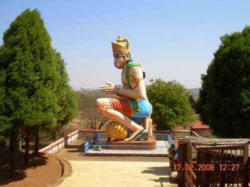
DUMURIPUT:-
Dumuriput
is a village located in between Koraput and Sunabeda by the side of N.H. 43.
The famous Ram Temple is situated there over a vast field. A 32 feet kneading
Hanuman statue attracts tourists passing by that road. Ram Navami festival is
celebrated have with Pomp and ceremony every year.
Kanta-baunsiani
(Thorn-Bamboo Goddess) –Damanjodi:-
One of the famous
Adivasi’s temple, of Odisha is Kanta-baunsiani (Thorn-Bamboo Goddess) in
Damanjodi of Koraput dist in Orissa. Adivasi literally translates to
‘’aboriginals’’. Adivasis have syncretic beliefs combining animism. Their
pantheon has both the common Hindu gods and their own. The gods and goddesses
are always attributed to various natural phenomena, objects, trees, animals,
etc. Damanjodi is a valley situated among the Panchpatmali hills. Except for
this bamboo forest, one can find no other bamboo tree in whole of Pancpatmali
hills.
Kanta-Baunsiani Devi in
Damanjodi is in the form of bamboos. These bamboos are revered as holy, not
only by the aboriginals but also worshipped by other people. Like any other
temple, there are no idols or a temple structure here. There are no fences for
these Bamboos. This temple is located very close to NALCO, Asia’s largest
Aluminum-Bauxite Mine. This Bamboo forest is the main temple for the local
indigenous tribes. It is a very famous temple in Damanjodi Area. it is Kanta-Baunsiani
is the reincarnation of Goddess Durga.


The Hindustan Aeronautics
Limited (H.A.L) is a Public sector company under the ministry of defence,
Government of India. Today it is the largest P & U under department of
defence production. It is now ranked 34th in the list of world’s top
100 defence companies. HAL Engine division Koraput is situated in Sunabeda
under Semiliguda block and about 18 Kms away from the district head quarters of
Koraput. It may be noticed here that HAL
is the first public sector undertaking in Odisha. Today HAL has emerged as a
major Aeronautical Complex in Asia. Today HAL has rich and enviable experience
of manufacturing more than 1000 aero engines and over hauling of over 4000 aero
engines.

HAL has entered into a number of joint ventures for
production and marketing of its products in India and international markets.
HAL has supplied Dhruv, Lancer, Chetak and cheetah helicopters and Do-228
aircraft to international customers; over the last six decades HAL has been
showing its capabilities in the field of air craft engineering catering to the
needs of Indian defence. The mission of HAL to become a global player in the
aerospace industry will be fulfilled. It is a pride of Odisha to have two
divisions of such a prestigious company in Koraput, a backward region.
DAMANJODI:-
Damanjodi is a town came to light with the
discovery of Bauxite mines in the Panchapatmali hills and setting up of Nalco,
the biggest Alumina Complex in Asia. Nearby stands the highest peak of Orissa.
The presiding deity “Kantabansuni”
is there in the bamboo forest which offers another attraction to tourists. It
is 35 Km away from Koraput. Prior permission is necessary from Nalco authority
for visiting this place.
.jpg)
DEOMALI:-
Deomali is the highest
mountain peak of Odisha in the eastern ghat.
Its height is 5800 feet above the sea level. It is an idyllic place for aero gliding and
trekking expedition. Tourists in large
number participate in trekking. Deomali
is an important Eco tourist place of Koraput district. Many tourists came to here to enjoy the
beauty of nature from the top of the Deomali hill. 3 view point has been made for tourists to
watch the beauty of the hill.

SEMILIGUDA:-
The village is the head
quarters of the Semiliguda police station in Koraput subdivision. Semiliguda is situated on Koraput Sunabeda
road at a distance of 15 Kms from Koraput.
A town ship is fast growing here.
The remains of a fort named “Dumb Fort” is found in this place. Recently an agriculture mixed farm has been
established in the village. Near
Semiliguda situated the beautiful “Mali Pahada”. Mali Pahada is surrounded by a beautiful
waterfall and dense forest, which attract the tourists to this place.
SUBEI:-
Some important Jaina
remains are found in Koraput district.
Among them Jain temple at Subei in the Koraput District of South Odisha
is now a most important tourist place.
This is the only surviving Jain temple in Odisha of the early medieval
time. The village Subei is located at a
distance of five miles from Nandapur of the Koraput District. Near the village, at the foot of the Panigiri
hill, are noticed Jaina Monuments.
Groups of Jaina temples at
Subei:- It is about 35 Km from Koraput on the main road leading to
Nandapur. The site is located near the
village Subei at the foot of Pangiri Hill.
Subei is situated at a
place of about 15 KM on the road between Semiliguda and Nandapur is an
important going a site. There is an old
Jain Monastery and some images of Tirthankars are found. There are large number of Jaina Sculptures
scattered in the forest near Subei.
There is a big Ganesh image near Subei.

NANDAPUR:-
In the
district of Koraput Nandapur is a place of natural beauty. And in the Nandapur block in Bhitargarh
remains the most beautiful waterfall named as Rani Duduma in Kutunimal
area. In winter season the place attracts
the tourists and nature lovers.
In the foot hill some important gods and goddesses are worshipped by the
tribal people. Till now the Sarbeswar
Temple, big stone idol of Ganesh about 6 feet high, Hanumana temple and
Batrishasinghasana (Throne with 32 steps) are the main attractions of Nandapur
town. Nandapur is 45 Km from
Koraput. Some important tourist places
of Nandapur area are Kutunimala, Chandan Mali Pahada, Rani Duduma waterfall,
Batrishasinghasana, broken image of Hati Pathara, Bhitargarh, Paruamali Gumpha
(cave), A Jina remains of Khemundiguda, Chatua, Ganesh temple etc. Near Nandapur in the places like Subai,
Paliba, Chatua and Khemundiguda, some Jaina remains and images are found. The Panthlung village of Nandapur and chandan
hill of Simla also attract the tourists.
Nandapur is about 14 miles from Semiliguda town. Historical remains and Jaina antiquities are
found in Nandapur. The village was
surrounded by a mud wall the remains of which are still noticeable. Nandapur
was the capital of the Old nandapur Kingdom.
In Nandapur
block of Panlung Panchayat remains the famous Raja Gumpha (cave) and Valmiki
Aashrama. The Raj Gumpha (cave) is
situated in the foot hill of “Nilama Hill” of Muktiamba village. The Raj Gumpha (cave) is three stored. The Sarveswara Siva temple of Nandapur is an
old site of Saiva worship. A Ganesh image near the Bhitaragarh areas is
another important spot, which has preserved one of the biggest sitting Ganesh
images in Odisha. The image measures 6
feet 5 inches (1.8 mtr) in height and 5 feet and 6 inches in breadth. The Bhairavi temple in the Bhitaragarh area
is nothing but a tin-roofed wooden structure.

JALAPUT:-
Jalaput is famous for a
major reservoir that is Jalaput reservoir on the river Machkund. The reservoir water is utilized for power
generation at Ankadeli. This place is
famous for Scenic beauty and a very good picnic spot. It attracts many tourists due to its natural spots
of beauty. This place is about 60 Km
from Koraput.

MACHKUND WATERFALL – DUDUMA:-
Machkund is about 49 miles
to the south of Jeypore. Near Badigoda
the river Machkund falls from a mountain top of 540. 19 feet as recorded by D.W Gollan on 4th
may 1929. Duduma is famous as the
highest waterfall of Odisha. From 1980
the place is identified as the main tourist spot of Koraput District. The Machkund waterfall is the beauty spot and
a main tourist spot of Koraput district.
A view tower is made to see the waterfall from long distance. Near the Duduma water fall remains the Banda
Pahada. The Machkund is regarded as the
famous Matsya Tirtha, a place of pilgrimage.

MACHKUND POWER HOUSE:-
This is the 1st
power house of Odisha. The next is Hirakud. It is a joint project of Odisha and
Andhra Pradesh. There are six units with 120 MW generating capacity. There is
one Winch of 20 metric ton capacity. During construction period all men and
materials were transported through this Winch. This is one of the most
attractive things for the visitors.
KECHELA:-
The village Kechela
situated on the southern bank of the river Kolab at a distance of 7 miles from
the Bagara waterfall. The village
Kechela is in Pottangi Tahasil situated near by the Koraput town.
After the construction of
modern reservoir on the river Kolab, presently one needs a boat to reach the
site. There is also a land route, but it
is long and not connected by bus or public conveyance. Remains of a Jaina temple was in existence on
the south of the Kechela village, but at present submerged in the Kolab water
reservoir.
Once upon a time it was a
strong hold of Jaina activity. To the
south of the village under the foot of the Deo Donger hill are noticed the
ruins of a stone temple and six sculptures of Jaina pantheon. It indicates that Kechela was a seat of
Jainism in the medieval period.

UPPER KOLAB:-
The river Kolab originates from within the Pottangi
plateau. After flowing for some
distance, the river flows down in several rapids and falls to the lower Jeypore
plateau. In the district of Koraput
upper Kolab Dam is one of the main tourist places. Inside the dam is beautiful park and its
natural beauty attracts many people from Koraput and outside the district. Inside the reservoir remain “Kechela Jaina
Temple”. Boating facility for the
tourists is also available in the reservoir.
Kolab Hydro Power Project has been constructed in the
upstream of the river Kolab originating from within the Pottangi Plateau. The Project is supplying drinking water to
Jeypore, Koraput, Sunabeda and Damanjodi.
It
is located at a distance of 15 Km from Jeypore.
At the toe of the Dam a Brindabana type garden has been developed. The area has been covered with a lot of
decorative and fruit bearing trees, shrubs and flowers buds. Local tourists come in large numbers for
picnic and enjoy the scenic beauty by the dam site. There is an ample scope for water sport in
the dam. Further development of dam site
and its surrounding would create ample scope for development of domestic
tourism besides the recreation facilities.

This tour to Koraput District is in-complete…
Visit again…
THANK YOU.